如何使用地图的注解功能

实现了协议MKAnnotation的对象才能够被用地图上的注解对象,一般都是如下定义的.
DisplayMap.h + DisplayMap.m
//
//  DisplayMap.h
//  MoreMapInfo
//
//  Copyright (c) 2014年 Y.X. All rights reserved.
//

#import <Foundation/Foundation.h>
#import <MapKit/MapKit.h>

@interface DisplayMap : NSObject <MKAnnotation>

@property (nonatomic, copy, readonly)   NSString                *title;
@property (nonatomic, copy, readonly)   NSString                *subtitle;
@property (nonatomic, assign, readonly) CLLocationCoordinate2D   coordinate;

- (id)initWithTitle:(NSString*)title
           SubTitle:(NSString*)subtitle
         Coordinate:(CLLocationCoordinate2D)coordinate;

@end
//
// DisplayMap.m
// MoreMapInfo
//
// Copyright (c) 2014年 Y.X. All rights reserved.
//
#import "DisplayMap.h"
@implementation DisplayMap
- (id)initWithTitle:(NSString*)title
SubTitle:(NSString*)subtitle
Coordinate:(CLLocationCoordinate2D)coordinate
{
if (self = [super init])
{
_title = title;
_subtitle = subtitle;
_coordinate = coordinate;
}
return self;
}
@endRootViewController.m
//
// RootViewController.m
// MoreMapInfo
//
// Copyright (c) 2014年 Y.X. All rights reserved.
//
#import "RootViewController.h"
#import <MapKit/MapKit.h>
#import "DisplayMap.h"
#import "LocationCoder.h"
#import "YXLocationManager.h"
@interface RootViewController ()<CLLocationManagerDelegate, MKMapViewDelegate>
@property (nonatomic, strong) MKMapView *mapView;
@end
@implementation RootViewController
- (void)viewDidLoad
{
[super viewDidLoad];
[YXLocationManager getCurrentLocation:^(CLLocation *location, NSError *error) {
if (error == nil)
{
// 将经纬度解析为地址
LocationCoder *lCoder = [[LocationCoder alloc] initWithLocation:location];
[lCoder startAnalyseLocation];
lCoder.resultBlock = ^(NSArray *placemarks, NSError *error,
LocationCoder *locationCoder)
{
NSLog(@"%@", locationCoder.addressLines);
};
//地图
_mapView = [[MKMapView alloc]initWithFrame:self.view.bounds];
_mapView.delegate = self;
_mapView.showsUserLocation = YES;
_mapView.mapType = MKMapTypeHybrid;
_mapView.region = MKCoordinateRegionMake(location.coordinate,
MKCoordinateSpanMake(0.1, 0.1));
//加入大头针
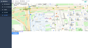
DisplayMap *anno = [[DisplayMap alloc]initWithTitle:@"title"
SubTitle:@"subtitle"
Coordinate:CLLocationCoordinate2DMake(39.928168, 116.39328)];
[_mapView addAnnotation:anno];
[self.view addSubview:_mapView];
//给地图添加长按手势,插上大头针
UILongPressGestureRecognizer* longPress = \
[[UILongPressGestureRecognizer alloc] initWithTarget:self
action:@selector(longPress:)];
[_mapView addGestureRecognizer:longPress];
}
else
{
NSLog(@"%@", error);
}
}];
}
#pragma mark - viewDidLoad UILongPressGestureRecognize longPress:
- (void)longPress:(UILongPressGestureRecognizer*)longPress
{
//长按一次 只在开始插入一次大头针 否则能用大头针写字。。。
if (longPress.state == UIGestureRecognizerStateBegan)
{
CGPoint point = [longPress locationInView:_mapView];
CLLocationCoordinate2D coordinate = [_mapView convertPoint:point
toCoordinateFromView:_mapView];
DisplayMap* an = [[DisplayMap alloc] initWithTitle:@"title"
SubTitle:@"subtitle"
Coordinate:coordinate];
[_mapView addAnnotation:an];
[_mapView setCenterCoordinate:coordinate
animated:YES];
}
}
#pragma mark - MKMapViewDelegate
- (MKAnnotationView *)mapView:(MKMapView *)mapView viewForAnnotation:(id<MKAnnotation>)annotation
{
//如果是所在地,跳过(固定写法)
if ([annotation isKindOfClass:[mapView.userLocation class]])
{
return nil;
}
// 重用
MKPinAnnotationView* pinView = (MKPinAnnotationView*)\
[mapView dequeueReusableAnnotationViewWithIdentifier:@"ID"];
if (pinView == nil)
{
pinView = [[MKPinAnnotationView alloc] initWithAnnotation:annotation
reuseIdentifier:@"ID"];
}
//能显示Call信息上面那些图字(很重要哦)
pinView.canShowCallout = YES;
//只有三种
pinView.pinColor = MKPinAnnotationColorPurple;
//显示动画 - 从天上落下
pinView.animatesDrop = YES;
pinView.image = [UIImage imageNamed:@"地图标点"];
// 左侧CalloutAccessoryView(使用了自定义view)
UIView* view = [[UIView alloc] initWithFrame:CGRectMake(0, 0, 100, 50)];
view.backgroundColor = [UIColor redColor];
pinView.leftCalloutAccessoryView = view;
// 右侧CalloutAccessoryView(使用了系统的按钮)
UIButton* button = [UIButton buttonWithType:UIButtonTypeDetailDisclosure];
pinView.rightCalloutAccessoryView = button;
return pinView;
}
- (void)mapView:(MKMapView *)mapView annotationView:(MKAnnotationView *)view calloutAccessoryControlTapped:(UIControl *)control
{
NSLog(@"点击事件");
}
@end打印信息:
2014-05-26 10:24:46.005 MoreMapInfo[6138:60b] AKLocation - [Line 118]
Started locating
==============
Distance filter accuracy: -1.00
Desired accuracy: 100.00
Timeout: 10.00
May 26 10:24:47 Phoenix MoreMapInfo[6138] <Error>: CGBitmapContextCreate: unsupported parameter combination: 5 integer bits/component; 16 bits/pixel; 3-component color space; kCGImageAlphaNoneSkipLast; 512 bytes/row.
2014-05-26 10:24:47.331 MoreMapInfo[6138:9c07] vImage decode failed, falling back to CG path.
May 26 10:24:47 Phoenix MoreMapInfo[6138] <Error>: CGBitmapContextCreate: unsupported parameter combination: 5 integer bits/component; 16 bits/pixel; 3-component color space; kCGImageAlphaNoneSkipLast; 512 bytes/row.
2014-05-26 10:24:47.372 MoreMapInfo[6138:8f0b] vImage decode failed, falling back to CG path.
2014-05-26 10:24:47.462 MoreMapInfo[6138:60b] 中国北京市东城区东四街道东四朝阳门北小街2-1号
May 26 10:24:48 Phoenix MoreMapInfo[6138] <Error>: CGBitmapContextCreate: unsupported parameter combination: 5 integer bits/component; 16 bits/pixel; 3-component color space; kCGImageAlphaNoneSkipLast; 512 bytes/row.
2014-05-26 10:24:48.363 MoreMapInfo[6138:a803] vImage decode failed, falling back to CG path.
May 26 10:24:48 Phoenix MoreMapInfo[6138] <Error>: CGBitmapContextCreate: unsupported parameter combination: 5 integer bits/component; 16 bits/pixel; 3-component color space; kCGImageAlphaNoneSkipLast; 512 bytes/row.
2014-05-26 10:24:48.375 MoreMapInfo[6138:a603] vImage decode failed, falling back to CG path.
May 26 10:24:48 Phoenix MoreMapInfo[6138] <Error>: CGBitmapContextCreate: unsupported parameter combination: 5 integer bits/component; 16 bits/pixel; 3-component color space; kCGImageAlphaNoneSkipLast; 512 bytes/row.
2014-05-26 10:24:48.402 MoreMapInfo[6138:9607] vImage decode failed, falling back to CG path.
May 26 10:24:48 Phoenix MoreMapInfo[6138] <Error>: CGBitmapContextCreate: unsupported parameter combination: 5 integer bits/component; 16 bits/pixel; 3-component color space; kCGImageAlphaNoneSkipLast; 512 bytes/row.
May 26 10:24:48 Phoenix MoreMapInfo[6138] <Error>: CGBitmapContextCreate: unsupported parameter combination: 5 integer bits/component; 16 bits/pixel; 3-component color space; kCGImageAlphaNoneSkipLast; 512 bytes/row.
2014-05-26 10:24:48.420 MoreMapInfo[6138:910b] vImage decode failed, falling back to CG path.
2014-05-26 10:24:48.421 MoreMapInfo[6138:9e07] vImage decode failed, falling back to CG path.
2014-05-26 10:25:10.317 MoreMapInfo[6138:60b] 点击事件


要点:
// 能显示Call信息上面那些图字(很重要哦)
pinView.canShowCallout = YES